L
A
I
N
C
O
L
O
R
P
H
O
T
O
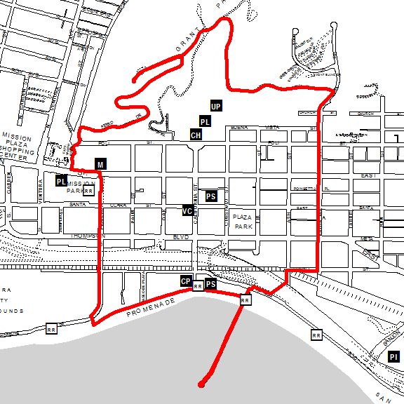
- West on the Promenade to the Surfers' Point Parking Lot (1584 feet = 0.30 miles so far) then
- North on Figueroa Street to Main Street (2273 feet = 0.73 miles so far) then
- North across Main Street to the Mission (62 feet = 0.74 miles so far) then
- West on Main Street to Valdez Alley (430 feet = 0.82 miles so far) then
- North up Valdez Alley to Poli Street (503 feet = 0.92 miles so far) then
- CAREFULLY Cross to the North Side of Poli Street (56 feet = 0.93 miles so far) then
- North on Cedar Street to Ferro Drive (174 feet = 0.96 miles so far) then
- Northeast up Ferro Drive to Brakey Road (2978 feet = 1.53 miles so far) then
- Out to the Grant Park Cross and Back (1665 feet = 1.84 miles so far) then
- Northeast on Brakey Road to Summit Drive (538 feet = 1.94 miles so far) then
- South and East on Summit Drive to Kalorama (3074 feet = 2.53 miles so far) then
- South on Kalorama to Poli Street (821 feet = 2.68 miles so far) then
- South on Kalorama Street to Front Street (1862 feet = 3.03 miles so far) then
- South across to the South side of Front Street (49 feet = 3.04 miles so far) then
- West on Front Street to Ash Street (460 feet = 3.13 miles so far) then
- South on Ash Street to the Footbridge (169 feet = 3.16 miles so far) then
- West over the Footbridge to the base of the Ventura Pier (797 feet = 3.31 miles so far) then
- To the End of the Pier and Back (3018 feet = 3.89 miles so far) then
- Down the Stairs from the Pier to the Promenade (92 feet = 3.90 miles so far) then
- West on the Promenade to the Crowne Plaza (707 feet = 4.04 miles)