L
A
I
N
C
O
L
O
R
P
H
O
T
O
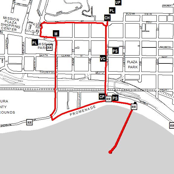
- South across Poli Street to the West side of California Street (168 feet = 0.03 miles so far) then
- South on California Street to Visitors' Center (840 feet = 0.19 miles so far) then
- South on California Street to Crowne Plaza (1214 feet = 0.42 miles so far) then
- East on the Promenade to the Stairs by the Ventura Pier (707 feet = 0.55 miles so far) then
- Up the Stairs from the Promenade to the Pier (92 feet = 0.57 miles so far) then
- To the End of the Pier and Back (3018 feet = 1.14 miles so far) then
- Down the Stairs from the Pier to the Promenade (92 feet = 1.16 miles so far) then
- West on the Promenade to the Crowne Plaza (707 feet = 1.29 miles so far) then
- West on the Promenade to the Surfers' Point Parking Lot (1584 feet = 1.59 miles so far) then
- North on Figueroa Street to Main Street (2273 feet = 2.03 miles so far) then
- North across Main Street to the Mission (62 feet = 2.04 miles so far) then
- West on Main Street to Valdez Alley (430 feet = 2.12 miles so far) then
- North up Valdez Alley to Poli Street (503 feet = 2.21 miles so far) then
- East on Poli Street to California Street (1763 feet = 2.55 miles so far) then
- North across Poli Street to City Hall (168 feet = 2.58 miles)